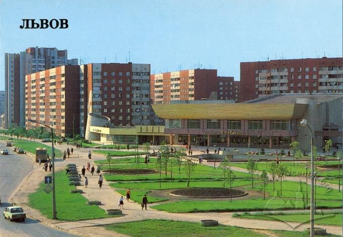
The photo was taken from an elevated vantage point, likely atop a low structure or a raised area on the opposite side of the street. The choice of location was deliberate — there is no surface at that spot from which the photo could have been captured without special equipment. This angle highlights the neighborhood’s distinctive features: the expansive open space before the buildings, the length of the residential area, and the neatly planned, youthful greenery. The panoramic shot captures a portion of the long Kryvorizka Street (now Chervonoyi Kaliny Avenue), constructed according to socialist modernization principles: straight lines, wide streets, and logical connections. The photograph has clearly undergone color correction typical of Soviet publishing houses; the editors enhanced the sky and increased the brightness of the greenery to emphasize the landscaping. The presence of residents in the image can be seen both as an effort to enliven the space and accentuate its scale (a common technique in Soviet architectural photography), and as a way to showcase a new lifestyle. In late Soviet discourse, the microdistrict became associated with young families, active workers, and a new culture of leisure in well-planned neighborhoods.
The district itself — Sykhiv — is not mentioned anywhere on the front of the postcard; only the city’s name appears. This choice reflects the idea that the front should serve as a visual symbol of the city and that text should not distract from the image. Nevertheless, it is notable that the city of Lviv is represented by a photograph of a densely built, high-rise district. Sykhiv, constructed at the end of the Soviet period, was envisioned as a socialist microdistrict. It became Lviv’s largest residential complex, intended to house 120,000 people. As Marcel Locard (1960) describes, a microdistrict is a residential ensemble designed to create an organic unity, bringing residents together through the daily use of shared social and cultural institutions (Sykhiv: Spaces, Memories, Practices, p. 24).
The O. P. Dovzhenko Cinema (now the Dovzhenko Center), which appears at the center of the postcard and opened in 1986, perfectly fits this description. From the outset, it was designed not only to screen films but also to host concerts, exhibitions, festivals, and creative gatherings. The area between the cinema and the fountain (although not visible on the postcard) has since become a public cultural space where various events for both residents and visitors to Lviv are held — for example, graduation ceremonies for local schoolchildren and art festivals for teenagers.
Behind the movie theater stand several nine-story P-44 series apartment buildings. Their inclusion on the postcard reflects the authors’ intention to highlight the state’s efforts to address the housing problem and create new, socially oriented housing, helping the city to “step into the future”. For this reason, new residential developments frequently appeared on Soviet-era postcards, alongside cultural and historical landmarks.
It’s important to note that these buildings were markedly different from their predecessors:
- separate rooms rather than walk-through rooms, which was a common issue in many “Khrushchev-era” buildings and earlier series,
- more spacious kitchens — typically 8–10 m² (compared to 5–6 m² previously),
- convenient zoning, featuring a clear separation between living and utility areas,
- loggias or balconies in nearly every apartment,
- a garbage chute — considered an advantage,
- elevators (one for passengers and one for cargo) in buildings with 9 or more floors.
The fourteen-story building in the background, located in the left corner of the postcard, deserves special mention as one of the high-rise landmarks along the avenue. Construction of these buildings required a special permit from the Council of Ministers of the Ukrainian SSR.
At the same time, the photograph’s angle enables the authors to conceal — or divert attention from — the challenges faced by Sykhiv’s new residents. The most prominent example is the fountain near the movie theater. Fountains played a symbolic role in Soviet residential areas, representing progress and modernization. Yet the photo clearly reveals that there is no water in this fountain, and this absence is intentional.
The microdistrict was designed to create “perfect” neighborhoods, structured to ensure a “fulfilling” life for the ideal Soviet citizen and to form an organic unity that separated the area from its natural and man-made surroundings. In their book The Future of the City (1977), A. Hutnov and I. Lezhava criticized this approach, arguing that it reduced the neighborhood’s natural environment to merely another piece of infrastructure (Sykhiv: Spaces, Memories, Practices, p. 27). Parks, lakes, waterways, and forests were valued only as long as they were needed and met residents’ demands. As a result, certain bodies of water were either maintained or allowed to fall into neglect, depending on necessity. This was the case with the fountain in question: it was initially intended as a cooling basin for the movie theater’s projector, but after a new projector was installed, the fountain became obsolete, was neglected, and fell into disrepair. According to accounts from contemporaries, it was actually used only twice: at the cinema’s opening and on Ukraine’s Independence Day (Sykhiv: Spaces, Memories, Practices, p. 45). Overall, water and nature in the area served purely utilitarian purposes, from drainage ditches to a drained lake once fed by the Zubra River. Later, the construction of a tank factory near Lviv rendered the water unfit for consumption.
This was one of the reasons why residents of the new high-rise buildings faced water problems. Supply was occasionally interrupted, and during the summer, there was often a severe shortage of hot water, forcing residents to purchase electric kettles. Meanwhile, the water supplied to apartments was considered undrinkable, so residents had to buy water in stores or from tanks placed in building entrances — a practice that continued well into the 2000s.
The second problem — which the authors concealed by “cutting off” the road on the left — was public transportation. Because the Soviet economy could not provide most citizens with private cars, the majority relied on public transport, which had not yet been fully developed when Sykhiv was rapidly populated. Bus routes were limited, as was often the case in suburban areas—a problem inherited by many post-Soviet cities. Trolleybus tracks were not added immediately, and the tram — planned since the 1970s — did not reach Sykhiv until 2016 due to material shortages. After independence, this issue in Sykhiv and other Lviv districts was addressed with the introduction of marshrutkas, which became one of the main modes of transportation for city residents.
The angle of the postcard also conceals the vast green wasteland that stretched behind the photographer. Plans once envisioned new cultural and recreational facilities for this area, such as a Pioneer Palace on the site where the Church of the Nativity of the Blessed Virgin Mary now stands. However, none of these planned facilities were ever built due to financial difficulties in the USSR during the 1980s, leaving citizens to make use of the green emptiness until the late 1990s.
The photograph lacks markers of distinctiveness or locality — the name “Dovzhenko” on the movie theater is the sole indication of the place’s Ukrainian identity. Portraying Lviv through a district of mass industrial housing integrates the city into the broader Soviet landscape, aligning it with other Soviet cities where, within the late-Soviet ideological project, the “single Soviet people” resided.
This postcard effectively fulfills its purpose: to present the city’s ceremonial side and convey the image of a “new Soviet district” within it. It serves both as a historical document attesting to Soviet printing and propaganda, and as a source on the city’s development and everyday life.
This postcard showcases the Sykhiv residential district in Lviv. The district’s name originates from the village of Sykhiv, which occupied this area from the 15th century until large-scale development began in the second half of the 20th century. The photograph was taken in the early 1980s, during the peak of the district’s construction. This is suggested by the completed street section in the image, while most of the trees in the foreground were recently planted, and the flower beds remain unlandscaped. The postcard was published in 1989 as part of a series depicting various city views.